Some tsunami-generating earthquakes are invisible to our monitoring systems.
Source: Live Science
The mysterious source of a globe-spanning tsunami that spread as far as 6,000 miles (10,000 kilometers) from its epicenter was an “invisible” earthquake, a new study has found.
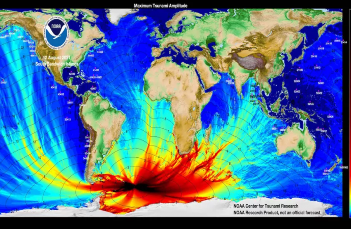
In August 2021, an enormous tsunami rippled out into the North Atlantic, Pacific and Indian oceans. It was the first time a tsunami had been recorded in three different oceans since the catastrophic 2004 Indian Ocean earthquake; at the time, scientists thought it was caused by a 7.5-magnitude earthquake detected near the South Sandwich Islands (a British Overseas Territory in the southern Atlantic Ocean).
But not everything was as it seemed. Scientists were baffled to find that the supposed epicenter of the earthquake was 30 miles (47 km) below the ocean floor, which is far too deep to cause a tsunami, and that the tectonic plate rupture that spawned it was nearly 250 miles (400 km) long — that kind of rupture should have caused a much larger earthquake.
Now, a new study published Feb. 8 in the journal Geophysical Research Letters, has revealed that the earthquake was actually a sequence of five sub-quakes, separated in time by mere minutes. And the third of these mini-quakes — a shallower, “invisible” earthquake hidden in the data and missed by monitoring systems at the time — was an 8.2-magnitude quake responsible for the tsunami.
“The third event is special because it was huge, and it was silent,” Zhe Jia, a seismologist at the California Institute of Technology, said in a statement. “In the data we normally look at [for earthquake monitoring], it was almost invisible.”
The researchers were able to retrieve the third quake’s signal from the tangle of seismic waves by chopping up the data into longer, 500-second chunks and using an algorithm to tease out its constituent parts. Only then did the 200-second quake, which Jia said made up 70% of the energy released during the entire event, appear. The hidden quake, which ruptured a 125-mile-long (200 km) interface between two plates, took place just 9.3 miles (15 km) beneath Earth’s surface — an ideal depth to spawn a tsunami.
The researchers say that the earthquake stayed hidden because it was a hybrid between two types of ocean earthquakes, the “deep rupture” type that results from a sudden slipping of plates, and a “slow tsunamigenic slip” created by a much slower, sometimes weeks-long grinding of one plate against another. Slow slip earthquakes can release just as much tectonic energy as a high-magnitude earthquake, but their slow pace, alongside the fact that they don’t cause any pronounced seismic shaking, can often make them hard to detect.
In fact, most earthquake and tsunami warning systems tend to focus on tracking the short to medium periods of seismological waves, leaving waves with longer periods, which are still capable of generating life-threatening tsunamis, buried inside the data, Jia said. The researchers want to change this, and have set out a long-term goal to design a system that can automatically detect and warn coastal regions about more complex tsunami-causing quakes in much the same way that current systems do for simpler ones.
“With these complex earthquakes, the earthquake happens and we think, ‘Oh, that wasn’t so big, we don’t have to worry.’ And then the tsunami hits and causes a lot of damage,” Judith Hubbard, a geologist at the Earth Observatory of Singapore who was not involved in the study, said in the statement. “This study is a great example of how we can understand how these events work, and how we can detect them faster so we can have more warning in the future.”
Source: Live Science











Leave a Comment
You must be logged in to post a comment.