NASA’s Mars helicopter Ingenuity captured stunning new aerial views of its landing site Jezero Crater during its most complex flight yet.
Source: Space.com
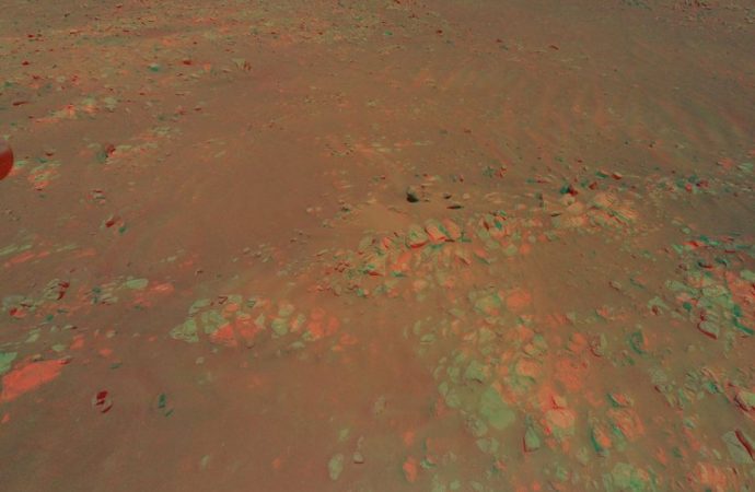
Ingenuity, which landed with the Perseverance rover inside Jezero Crater, an ancient, Martian lakebed, on Feb. 18, completed its 10th flight on July 24, climbing to a new record altitude of 40 feet (12 meters). From this vantage point, Ingenuity was able to photograph low-lying wrinkles, or “Raised Ridges,” in the crater’s surface, which may reveal new clues about Mars’ watery past, according to a statement from NASA’s Jet Propulsion Laboratory (JPL).
“Ingenuity is allowing the Perseverance science team to be in two places at once,” Kevin Hand, a scientist at JPL and co-lead of Perseverance’s first science campaign, said in the statement. “Right now, we are at the ‘Crater Floor Fractured Rough,’ where the rover is preparing for the mission’s first sample acquisition on Mars. Yet at the same time, Ingenuity is providing a detailed preview of a potentially intriguing geologic features hundreds of meters away from us.”
During its 10th flight, the helicopter took off from its seventh airfield and flew about 310 feet (95 m) before landing at a new airfield. From take off to landing, the entire flight lasted just under 3 minutes, during which the helicopter snapped 10 photos using its color camera.
The team then created a 3D view of the Raised Ridges area using two of the images that were taken during its flight. The images were taken only a few meters apart, from an altitude of 40 feet (12 meters). This area interests the Mars Perseverance rover science team because it consists of three distinct surface fractures that converge at a central point — similar to fractures seen in desert environments on Earth that offer possible clues about past water activity in the area.
“In 3D it almost feels like you can reach out and touch the Raised Ridges,” Hand said in the statement. “But along with its immersive beauty, the image provides great detail. If you look closely, you can see some curious lines across the surfaces of several rocks. Are these just made by eons of wind and dust blowing over the rocks, or might those features tell the story of water? We just don’t know yet.”
One of Perseverance’s key mission objectives is to search for signs of ancient microbial life on Mars. By using the new Ingenuity images, the team can better assess whether or not to send Perseverance to collect a sediment sample from the Raised Ridges, given it would take several Martian days, or sols, for the rover to reach the area, according to the statement.
“Since landing at Jezero Crater, it’s clear to all of us that there is an abundance of geologic riches for us to explore. It’s a good problem to have,” Ken Williford, deputy project scientist for Perseverance at JPL, said in the statement. “These aerial previews from Ingenuity provide the kind of actionable data that allow us to whittle down our options and get on with the business of exploring our corner of Mars.”
Following this flight, Ingenuity made its 11th Martian flight Thursday morning (Aug. 5). During this next flight, the helicopter traveled 1,250 feet (380 m). The flight aimed to take the helicopter to a new airfield where Ingenuity can investigate the rough terrain of the South Séítah region up close.
Source: Space.com























Leave a Comment
You must be logged in to post a comment.