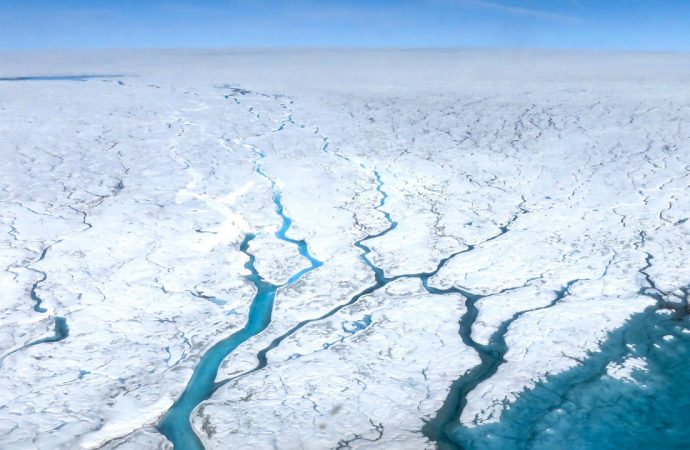
Global warming is accelerating the melting of Greenland’s ice sheet, which locks up enough water to raise sea levels by 7 meters.
Source: Science Mag
In 2021, U.S. researchers will go to the frozen expanse to pinpoint the last time it disappeared. The 5-year, $7 million campaign, awarded last month by the National Science Foundation, will mark the first large U.S. ice drilling program in Greenland in more than 25 years. Unlike past projects, the target is not the climate records held in the ice, but the rocks below, which contain radioactive clocks that show when they were last exposed to air. “The whole bedrock is an archive,” says Joerg Schaefer, a geochemist at Columbia University and co-leader of the project, called GreenDrill. “It’s just a question of getting these freaking samples under the ice.”
Greenland already accounts for 25% of global sea level rise, and that share is growing. Scientists have recently identified the island’s north as a hot spot for melting during the next century. The drilling project could not only validate those near-term fears, but also inform climate models that struggle to predict the long-term fate of the ice.
As a bonus, the effort could shed light on the timing of the asteroid or comet impact that gouged the Hiawatha crater, a 31-kilometer scar hidden under the ice, sometime within the past 3 million years. Some scientists think the event was recent and the trigger for a bout of global cooling 13,000 years ago known as the “Younger Dryas.” But so far, no firm dates have been recovered from crater material to support that controversial claim. Although GreenDrill researchers will not drill into the crater itself, one of its four sites is just 20 kilometers to the west. Rocks there could show when the ice last melted away—perhaps in the sudden heat of the impact. And any impact ejecta recovered in the rock could be sifted for minerals, such as zircons, that offer precise dates.
The larger goal of the project, however, is mapping the ebb and flow of the ice sheet over the past million years. The last major U.S. effort, the Greenland Ice Sheet Project 2 (GISP2), cored 2 kilometers of ice on its way to hitting bedrock in 1993. GreenDrill will not go nearly as deep, but will make up for it in volume. Each of the four sites will have three holes in a transect running toward the shore: one through 300 meters of ice, one through 100 meters, and one on exposed rock near the ice’s edge. It will be a major operation, says Henriette Linge, a geologist at the University of Bergen. “It’s very promising that they’ll get information otherwise beyond our reach.”
The history of the ice is written in the rocks it covers. Cosmic rays create trace amounts of radioactive isotopes when they strike exposed rock and soil; ice blocks these rays, and so the resulting radioactive decay provides a clock for when the ground last saw light. In 2016, Schaefer used rocks from GISP2 to show that the ice covering the site melted sometime in the past million years, counter to prevailing beliefs that the sheet had been stable for several million years. Last year, preliminary work on dirt from another core in northwest Greenland, Camp Century, seemed to support that finding.
There are two prime suspects for when the ice sheet could have last collapsed: warm periods some 420,000 and 140,000 years ago. Both saw temperatures like today’s, due to natural wobbles in the planet’s tilt and orbit, but it’s unclear whether the warmth lasted long enough to melt the entire ice sheet. Knowing whether the past warmings were enough to erase the ice is crucial to gauging the sea-level threat from Greenland today, says Paul Bierman, a geochemist at the University of Vermont who is not involved in the drilling campaign. “This project is one of the most important pieces of science we can do on Greenland.”
GreenDrill will target rock rich in minerals that contain five isotopic tracers, including chlorine-36, which has a brisk, 300,000-year half-life. The clock’s sharp time resolution should help researchers discern whether the ice disappeared during either of the warm periods, and how long it took to melt. Although the four sites cannot say for certain what happened elsewhere on the ice sheet, patterns of exposure between the 12 cores, integrated in a next-generation ice sheet model, will be able to constrain the ice loss.
The fate of Greenland’s ice sheet amid modern warming is a drama that will play out over many centuries. But GreenDrill could also help in understanding shorter term ice loss in northern Greenland, which scientists now fear is more sensitive to melt than its south. The amplification of climate change in the Arctic means the high-latitude region is warming faster and shedding more ice than anywhere else in Greenland. Another reason for its vulnerability: As sea ice disappears, the north’s low-lying inland glaciers could lose a protective buttress.
Using a fast clock based on carbon-14 isotopes found in the rocks, researchers could discover whether some of the northern GreenDrill sites were briefly exposed 8000 years ago, when regional temperatures were 3°C warmer than now, says Jason Briner, a geologist at the University at Buffalo and project co-leader. Evidence suggests the southern ice sheet was stable during the warm episode; finding that the ice in the north retreated, Briner says, would cement its place as a worrisome new climate hot spot.
Source: Science Mag













Leave a Comment
You must be logged in to post a comment.