There’s nothing usual about the magnitude of this Sahara Desert sandstorm that is almost circling the globe. It has made it to the U.S., will it touch Canada?
Source: The Weather Network
The dust plume was Caribbean island hopping over the weekend and into the beginning of the week, fully blocking out the sun along its path. This unusually powerful sandstorm is even continuing strong into the US, providing some hazy days for parts of Texas.
The risks that are associated with sandstorms of this magnitude include visibility and respiratory issues. The latter even being a concern for healthy people. There could also be risks of allergins when the dust settles. But, the risks aren’t too high.
 June 25 observation
The Caribbean meteorologists recommend that everyone should wear a mask, which should already be happening from coronavirus. They also say that people should stay inside and drink lots of water.
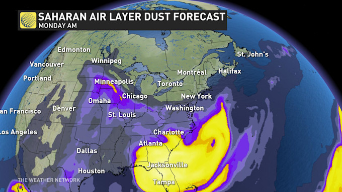
The same advice could be relayed to Texas, which seems to be the first area of the US where these storms are occurring. The sandstorm is currently sitting in the Gulf Coast and in southeast areas of the US. The winds could carry the dust toward and into Alabama and Georgia.
Saturday, it looks like the dust will continue along the southeast states, touching Alabama, Georgia, and the Carolinas.
The storms do get close to Manitoba, though they will likely miss. The province could just experience some hazy conditions.

This beast of a dust storm looks like it will have the energy to almost fully circle the globe before it subsides in Portugal.
The dust clouds are so expansive and dense, that they can clearly be seen from satellite views and the International Space Station. The storm is being dubbed the “worst in the last 50 years.”
Source: The Weather Network


Leave a Comment
You must be logged in to post a comment.