The volcano is responsible for the deadliest eruption in the U.S., yet many mysteries remain about the closely watched peak, including why it formed in the first place.
Source: National Geographic
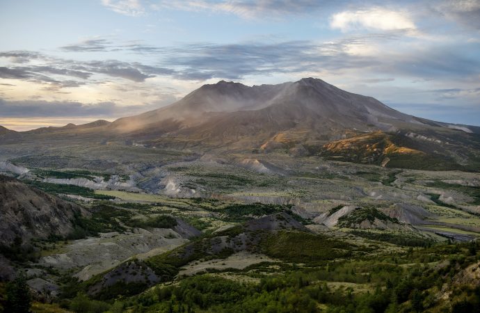
The frosty volcanic peaks of the Pacific Northwest stand in a remarkably straight line, rising from the crumpled landscape east of Interstate 5. But one volcano is conspicuously out of place. More than 25 miles to the west of the other explosive peaks, in the southwest corner of Washington State, sits Mount St. Helens.
It’s been 40 years since Mount St. Helens famously roared to life, sending ash and gas 15 miles high, flattening 135 square miles of forest, and killing 57 people in the country’s deadliest eruption. Today, the volcano is still one of the most dangerous in the United States, and the most active of the Cascade Range.
Where all this firepower comes from, however, has been an enduring mystery. The volcano’s defiant position out of line perches it atop a zone of rock too cold to produce the magma necessary to feed its furious blasts.
“There shouldn’t be a volcano where Mount St. Helens is,” says Seth Moran, scientist-in-charge at the U.S. Geological Survey’s Cascades Volcano Observatory in Vancouver, Washington.
Solving this puzzle is about more than satisfying geologic curiosity. The firestorm 40 years ago was a reminder of the dangers the Cascade volcanoes pose to millions of people—and a hard shove propelling volcanology into the future. In the decades since, scientists have used the extensive observations of that blast to better understand eruptions around the world, and bolster our readiness for those yet to come.
“This was a fundamental leap forward in our understanding of this style of eruption,” says Janine Krippner, a volcanologist with Smithsonian’s Global Volcanism Program.
Crucially, a more detailed view of the volcano’s inner workings could help researchers better track the shudders and shifts that foreshadow an eruption, potentially helping to hone volcanic forecasts and get people out of harm’s way.
Four decades after Mount St. Helens’ eruption, scientists finally are unearthing some clues to its curious position. In one of the most comprehensive efforts to trace a volcano’s roots, the Imaging Magma Under St. Helens project, or iMUSH for short, used a slew of analyses to bring these subterranean secrets to light. Overall, the volcano doesn’t follow the textbook picture of a peak sitting above a chamber of molten rock. Instead, it seems, a diffuse cloud of partially molten blobs lingers deep below the surface, offset to the east of the edifice, toward the neighboring Mount Adams.
View from the sky
On the crisp, clear morning of May 18, 1980, geologists Dorothy and Keith Stoffel were soaking up glorious views of Mount St. Helens from the air. As a special treat for Dorothy’s upcoming 31st birthday, the pair had secured permission from the USGS to charter a flight over the volcano. It had been rumbling for nearly two months, but the mountain was almost tranquil early that Sunday. When Dorothy called the USGS to check if the flight was a go, she was told: “Come on over, there’s nothing happening here.”
Usually covered in snow and glaciers, Mount St. Helen’s white flanks had been blackened by the volcano’s recent burbles. The pair snapped pictures of the symmetrical peak from the windows of the Cessna 182. “It was so calm and serene, I almost felt a sense of disappointment,” Dorothy recalls. “In my mind, I thought, Oh, the mountain’s become dormant again.”
A swollen bulge that protruded from its northern flank was one of the few visual reminders of its active state. Since late March of that year, the bulge had grown six and a half feet each day. As the Stoffels flew by, Dorothy spotted glistening white tracks of melted ice rolling down the volcano’s ashen face, a sign of the intense heat just below the surface. The plane then looped across the sky, eventually making two passes over the volcano’s crater.
At 8:30 a.m., they decided to make one last arc heading east above the bulge. That was when the volcano suddenly unraveled.
Faster than they could comprehend what was happening, a crack more than a mile long split the mountain, and the north side collapsed in the largest landslide ever recorded above water. The pair continued snapping images as the ground seemed to liquify, and more than 0.6 cubic miles of material—enough to fill a million Olympic swimming pools—churned downslope.
“As a geologist, you expect volcanoes to erupt,” Dorothy says. “You do not expect mountains to instantly fall apart.”
The landslide released the pressure on the magma building below—like popping the cork of a champagne bottle—and the volcano let loose. Billowing clouds of hot rock jetted northward in a massive sideways blast, the first of its kind observed in detail. Traveling as fast as 300 miles an hour, the explosion sheared the peak off the volcano, and wreaked devastation across hundreds of square miles.
Swelling clouds from the sideways blast began to overtake the Stoffels’ plane. The pilot dropped into a nosedive to gain speed. “I really thought our lives were over,” Dorothy says. But by veering south, the trio narrowly escaped.
As they retreated, Dorothy watched the plume of searing gas and ash billow skyward, flashes of volcanic lightning illuminating the crater. For more than nine hours, the plume towered over the volcano, blanketing the region in ash and blotting out the sun.
The Stoffels’ harrowing account is a vital piece of information among the numerous observations of the explosive event recorded by both citizens and scientists. Nearly 34 miles to the east, on Mount Adams, climber John Christiansen, raised his ice ax to the sky. The air was so electric, it shocked him through his woolen mitten. Some 45 miles to the southwest, on Oregon’s Sauvie Island, artist Lucinda Parker and her husband tracked the roiling plume as their three-year-old daughter played in the sand. More than 145 miles to the east, Douglas Bird and his family were leaving for church when he spotted the approaching clouds laden with ash, unlike anything he’d seen before.
The power of the blast has echoed through generations and brought researchers from around the world to Washington State to study the volcano. The iMUSH project was, in part, born from this intense fascination.
Peering into the deep
Mount St. Helens is a member of the Cascadia volcanic arc, which stretches from British Columbia to Northern California. Similar to many volcanoes around the world, this simmering range is the product of a subduction zone, a tectonic collision where, in this case, a dense oceanic plate plunges beneath a more buoyant continental plate. As the slab descends, pressures and temperatures climb, and fluids percolate out of the slab, triggering the solid mantle rocks to melt. Less dense than its surroundings, this molten magma shoves its way upward through the crust, creating volcanoes.
Most of the Cascade volcanoes—and others around the world—take shape above the spots where the plunging slab descends to roughly 62 miles deep, where temperatures get high enough for magma to form. But the situation is different at Mount St. Helens. Standing tens of miles to the west of other volcanoes, the infamous peak perches a mere 42 miles above the subducting plate.
The iMUSH project kicked off in the summer of 2014 in part to try and solve this conundrum. To craft images of the subsurface, scientists can study the speed at which seismic waves travel and their path underground; it’s not unlike taking a planetary ultrasound. Battling flat tires and unmaintained dirt roads, dozens of researchers assembled to deploy a fleet of seismometers all over the volcano’s flanks.
For one part of the analysis, the researchers detonated a series of blasts and watched the waves roll in. Another set of instruments recorded every tremble around the peak—such as the rumble of ocean waves and earthquakes on the other side of the world—for two years. Other researchers tackled the system by studying the chemistry of the rocks themselves. And still more scientists used Earth’s magnetic and electric fields to map out the conductivity of the subsurface.
“As far as the group was able to do, the kitchen sink got thrown at St. Helens,” says the USGS’s Moran, who was part of the iMUSH team.
The results show that seismic waves creep along slowly in a zone east of Mount St. Helens, some 10 to 25 miles deep. Differences in minerals can influence the speed of seismic waves, but magma can be another source of this sluggishness. Perhaps rocks melt as expected near the rest of the Cascade volcanoes, the analysis suggests, but some diverts westward to squeeze through the subsurface and feed Mount St. Helens.
The story from the rocks themselves fits with this picture. By melting samples of erupted rock under a variety of conditions in the lab, the team revealed that the sticky gas-rich magmas that give Mount St. Helens eruptions their punch form at a depth similar to the proposed reservoir, says Dawnika Blatter, an experimental petrologist on the iMUSH team who works with the USGS’ California Volcano Observatory.
The surprising offset of this magma “suggests we need to look more broadly than just right below a volcano if we’re going to understand where the magma is coming from,” says Geoffrey Abers, a geophysicist at Cornell University who was part of the iMUSH seismic analyses.
After the 1980 eruption, researchers may have even caught trembles from nearby this deep melt zone, as the earth adjusted to the draining of molten rock. For nearly a year after the blast, Moran says, tremors rumbled to the southeast of the peak. Subterranean shifts in magma can produce quakes around volcanoes, so knowing whether these tremors are in fact linked to Mount St. Helens’ magma pockets could help direct future monitoring efforts.
“We’ve known that the southeastern side of St. Helens is a little bit of a weak spot in the network,” Moran says. “Having insight into reasons why earthquakes are occurring out there gives more impetus to improving that side of the volcano.”
Ancient scars
The choreographer of this magmatic dance is still being debated. Many scientists see clues in the surrounding landscape, which bears scars from millions of years of tectonic jostling that could help direct the modern flow of molten rock.
A volcanic plateau known as Siletzia once sat off North America’s west coast. But Earth’s continuous tectonic shifting slowly closed the gap, and some 50 million years ago, Siletzia collided with the continent. As the ocean between the two landmasses closed, seafloor sediments were scraped into a heap beneath the surface and squeezed into stone. According to the iMUSH team, this indelible tectonic suture may lie just beneath Mount St. Helens.
The scientists sketched out structures from this merger using a method known as Magnetotellurics, which tracks the conductivity of rocks. Minerals that are carbon- and sulfur-rich, similar to those that might form from marine sediments, “light up like a Christmas tree,” says Paul Bedrosian, a geophysicist with the USGS and a member of the iMUSH team. Sure enough, just beneath Mount St. Helens, a swath of such illumination marks the region where ancient marine sediments were turned into a particular rock type called metasedimentary.
The analysis unveiled another surprise just to the east of the volcano: A vast area of low-conductivity rock sits just above where deep magma may pond. The scientists believe this rock is a slug of now-cooled magma that formed millions of years before Mount St. Helens was born.
The differences in the properties of this volcanic plug, known as a batholith, and the metasedimentary rocks of the suture zone may alter the stresses in the region and thus direct the magma flow. The batholith limits magma from rising to the east of Mount St. Helens; the metasedimentary rocks could serve as a relief valve, drawing the volcano’s sticky, viscous magma to the surface.
A dense wall of rock beneath these metasediments, also revealed by the seismic array, may actually be part of this lost landscape, providing a westward stop for the flow of magma, says Jade Crosbie, a geophysicist with the USGS in Lakewood, Colorado, and part of the iMUSH team.
Navigating a sea of data
While the iMUSH analyses help sharpen our view deep inside the planet, the picture remains far from complete, Moran says. “One of the general rules in geophysical imaging is the deeper you go, the less you know.” Volcanoes 101 About 1,500 active volcanoes can be found around the world. Learn about the major types of volcanoes, the geological process behind eruptions, and where the most destructive volcanic eruption ever witnessed occurred.
Today, the remains of Siletzia can be seen only piecemeal at the surface, partially buried by flows of now solidified lava and soils studded with trees. This leaves scientists debating where the suture zone—and its role in magmatic direction—precisely lies. To actually put your hand on Siletzia rocks, you’d have to travel tens of miles to the west of Mount St. Helens, says seismologist Eric Kiser of the University of Arizona, who was an iMUSH team member.
As the researchers continue to sort through the sea of other data from iMUSH, many more questions dance in their heads. How does the system change over time? How quickly does the magma move? How does such a vast zone of partly melted rock focus into a volcanic pinprick on the surface? Each potential answer helps shape our understanding of how and why volcanoes erupt, which can help researchers connect what happens at one volcano to the broader picture of volcanism around the world, says seismologist Helen Janiszewski of the University of Hawaii at Manoa.
Since that fateful day in 1980, Mount St. Helens has awoken multiple times, even as the population living in its shadow has grown. That confluence reinforces the need to keep close watch on this particular peak, and scientists have embraced that task.
“Mount St. Helens is being monitored really well,” Kiser says. “The USGS people, they’ve got that under control.”
Source: National Geographic



















Leave a Comment
You must be logged in to post a comment.