The newly-discovered river system was active as recently as 15,000 years ago beneath an area formerly covered by the East Antarctic ice sheet, according to new research published in the journal Nature Geoscience.
Rice University postdoctoral researcher Lauren Simkins and colleagues analyzed sediment cores and seafloor maps of the deglaciated western Ross Sea.
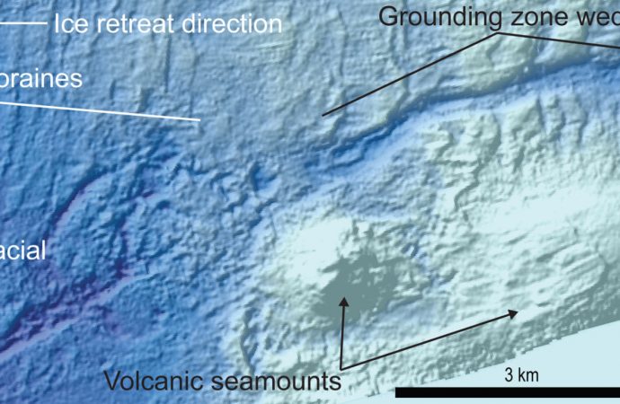
The maps were created from state-of-the-art sonar data collected by NSF’s research vessel Nathaniel B. Palmer.
They revealed how the ice retreated during a period of global warming after Earth’s last Ice Age.
In several places, the maps show ancient water courses — not just a river system, but also the subglacial lakes that fed it.
“Because of the paucity of information about how water presently flows beneath Antarctic ice, the fossilized river system offers a unique picture of how Antarctic water drains from subglacial lakes via rivers to the point where ice meets sea,” Dr. Simkins said.

This schematic depicts a subglacial Antarctic river and overlying ice sheet; black lines t1, t2 and t3 show where the ice sheet was grounded to the seafloor during pauses in ice retreat; the authors used such lines from precise maps of the Ross Sea floor to study how liquid water influenced the ice sheet during a period of its retreat starting about 15,000 years ago. Image credit: L. Prothro, Rice University.
The contemporary observations scientists have of Antarctic hydrology are recent, spanning maybe a couple decades at best.
This is the first observation of an extensive, uncovered, water-carved channel that is connected to both subglacial lakes on the upstream end and the ice margin on the downstream end.
“The size and scope of the fossilized river system could be an eye-opener for ice-sheet modelers who seek to simulate Antarctic water flow,” added co-author Dr. John Anderson, Maurice Ewing Professor of Oceanography at Rice University.
“For example, the maps show exactly how ice retreated across the channel-lake system. The retreating ice stream in the western Ross Sea made a U-turn to follow the course of an under-ice river.”
“It’s the only documented example on the Antarctic seafloor where a single ice stream completely reversed retreat direction, in this case to the south and then to the west and finally to the north, to follow a subglacial hydrological system.”
Another key finding of this work is that drainage through the river system took place on a time scale measured in tens to several hundreds of years.
Source: Sci News









Leave a Comment
You must be logged in to post a comment.