NASA’s prolific Mars Reconnaissance Orbiter turns five Earth years old Thursday
Since settling into orbit around the Red Planet on March 10, 2006, MRO has transmitted more data to Earth — 131 trillion bits and more than 70,000 images so far — than all other interplanetary missions combined.
After the orbiter finished all its initial science objectives in the first two years, NASA extended its lifetime twice. The extra time let MRO watch Mars change over two-and-a-half Martian years, giving a new picture of a shifting, dynamic planet.
“Each Mars year is unique, and additional coverage gives us a better chance to understand the nature of changes in the atmosphere and on the surface,” said Rich Zurek of NASA’s Jet Propulsion Lab in a press release. “We have already learned that Mars is a more dynamic and diverse planet than what we knew five years ago. We continue to see new things.”
MRO carries six science instruments, including radar that peels back the layers of the Martian surface, a spectrometer that has mapped the mineral content of three-quarters of the planet, and a weather camera that monitors clouds and dust storms.
But the show stopper is the HiRise camera (High Resolution Imaging Science Experiment), which can resolve features the size of a beach ball from 180 miles away.
To date, HiRise has snapped more than 18,500 close ups of Mars’ canyons, craters and dunes. In honor of MRO’s fifth birthday, here are some of our favorites.
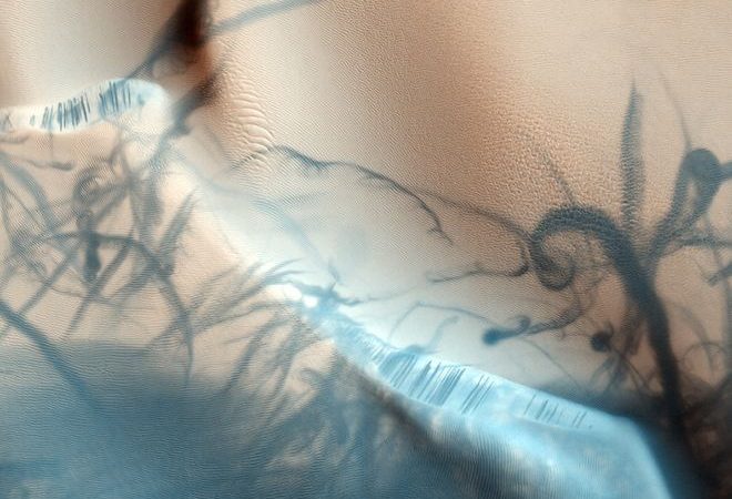
Above:
Dust-Devil Tattoo
These twisty trails were traced by dust devils, spinning columns of rising air that pick up loose red dust grains and reveal darker, heavier sand beneath. Dust devils have been blamed for unexpectedly cleaning off the Mars rovers’ solar panels. This image was taken Aug. 24, 2009.

You Are Here
This stunning view of the half-mile-wide Victoria Crater was taken Oct. 3, 2006. The Mars rover Opportunity, which arrived at Victoria five days before this image was taken, is perched at the crater’s edge (below). Opportunity explored Victoria crater until August 2008.
 HiRise is still checking in on Opportunity. The image below was taken March 1, 2011, as Opportunity explored the rim of a 295-foot-wide crater called Santa Maria.


Avalanche Clouds
Last winter, HiRise caught an avalanche in action. This image, taken Jan. 27, 2010, shows at least three clouds of dust kicked up as a clump of carbon dioxide ice fell 2,000 feet from the cliff face. The ice was probably dislodged by warming temperatures and sunlight, as the Martian winter turned to spring.
This was the second avalanche HiRise watched. The first, on Feb. 19, 2008 (below), caught material skidding down a sleep slope to make clouds almost 600 feet wide.


Lovely Layers
This image, captured Nov. 8, 2006, shows layers of lighter and darker material, probably laid down over millions of years as Mars’ climate slowly and cyclically changed.
The layers wouldn’t really look yellow and blue if you were standing on Mars. HiRise takes images in three colors: blue-green, red and the invisible near infrared. The color images are then stacked on top of one another and displayed in visible red, blue and green to highlight different geological features.

Falling Phoenix
MRO was in just the right spot May 25, 2008, to catch the Mars Phoenix Lander parachuting to the surface. MRO was 472 miles away and zipping by at about 2 miles per second when it shot this photo.
Through a trick of perspective, Phoenix looks like it’s about to fall into the 6-mile-wide Heimdall crater. It’s actually about 12 miles away from the crater’s edge.

Veins of Water
Veiny gullies trace the walls of a large pit in Mars’ southern hemisphere in this image, captured Aug. 5, 2007. The gullies may have been carved by liquid water millions of years ago, when Mars was warmer and wetter.

Starburst Spider
Every Martian spring, the seasonal cap of frozen carbon dioxide (dry ice) shifts directly from solid to gas without bothering to melt first. This sublimation erodes beautiful patterns in the soil, like the dendritic spider patterns in this image captured Feb. 4, 2009.

Southern Swiss Cheese
Mars’ south pole is a weird place. Permanent ice caps are carved into smooth, swirling shapes that planetary scientists call “Swiss cheese terrain.” The high-standing areas are carbon dioxide ice up to 30 feet thick. The depressions are thought to be gouged out by the removal of this carbon dioxide ice by sublimation — changing directly from solid to gas.
HiRise has been monitoring the south polar caps closely for changes. The image above was captured Aug. 28, 2007. In the image below, captured Dec. 30, 2010, the pits have grown to resemble a wonky happy face.


Winter Dunes
Dunes and ripples of many sizes take center stage in this image taken Nov. 25, 2006. The bright tones are thought to be carbon dioxide or water frost.

Preparing the Way
MRO is also helping to choose the next Mars rover’s destination. This image from June 15, 2009, shows a patch of one of the final four candidates, Eberswalde Crater. Eberswalde lies next to a wide, meandering delta, thought to be some of the best evidence that Mars once had persistent water.
Source: Wired.com
Images: NASA/JPL/University of Arizona











Leave a Comment
You must be logged in to post a comment.