Earth’s gravitational field is depicted not as a solid body, but as a dynamic surface that varies over time.
People tend to think of gravity here on Earth as a uniform and consistent thing. Stand anywhere on the globe, at any time of year, and you’ll feel the same downward pull of a single G. But in fact, Earth’s gravitational field is subject to variations that occur over time. This is due to a combination of factors, such as the uneven distributions of mass in the oceans, continents, and deep interior, as well as climate-related variables like the water balance of continents, and the melting or growing of glaciers.
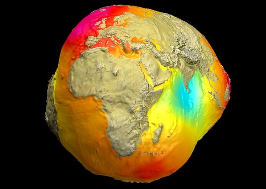
And now, for the first time ever, these variations have been captured in the image known as the “Potsdam Gravity Potato” – a visualization of the Earth’s gravity field model produced by the German Research Center for Geophysics’ (GFZ) Helmholtz’s Center in Potsdam, Germany.
And as you can see from the image above, it bears a striking resemblance to a potato. But what is more striking is the fact that through these models, the Earth’s gravitational field is depicted not as a solid body, but as a dynamic surface that varies over time. This new gravity field model (which is designated EIGEN-6C) was made using measurements obtained from the LAGEOS, GRACE, and GOCE satellites, as well as ground-based gravity measurements and data from the satellite altimetry.
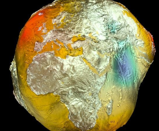
The 2005 model, which was based on data from the CHAMP and GRACE satellites and surface data, was less refined than the latest one. Credit: GFZ
Compared to the previous model obtained in 2005 (shown above), EIGEN-6C has a fourfold increase in spatial resolution.
“Of particular importance is the inclusion of measurements from the satellite GOCE, from which the GFZ did its own calculation of the gravitational field,” says Dr. Christoph Foerste who directs the gravity field work group at GFZ along with Dr. Frank Flechtner.
The ESA mission GOCE (Gravity Field and Steady-State Ocean Circulation Explorer) was launched in mid-March 2009 and has since been measuring the Earth’s gravitational field using satellite gradiometry – the study and measurement of variations in the acceleration due to gravity.
“This allows the measurement of gravity in inaccessible regions with unprecedented accuracy, for example in Central Africa and the Himalayas,” said Dr. Flechtner. In addition, the GOCE satellites offers advantages when it comes to measuring the oceans.
Within the many open spaces that lie under the sea, the Earth’s gravity field shows variations. GOCE is able to better map these, as well as deviations in the ocean’s surface – a factor known as “dynamic ocean topography” – which is a result of Earth’s gravity affecting the ocean’s surface equilibrium.
Source: Unversetoday











Leave a Comment
You must be logged in to post a comment.